
Pre-release. Ophiolite runs today for design partners; public source and server image publication are in preparation.

Product

Six things Ophiolite does

One project on your own server keeps exact versions of your data with their context. These are the six things it does, each with its status today.

Workspace

Available

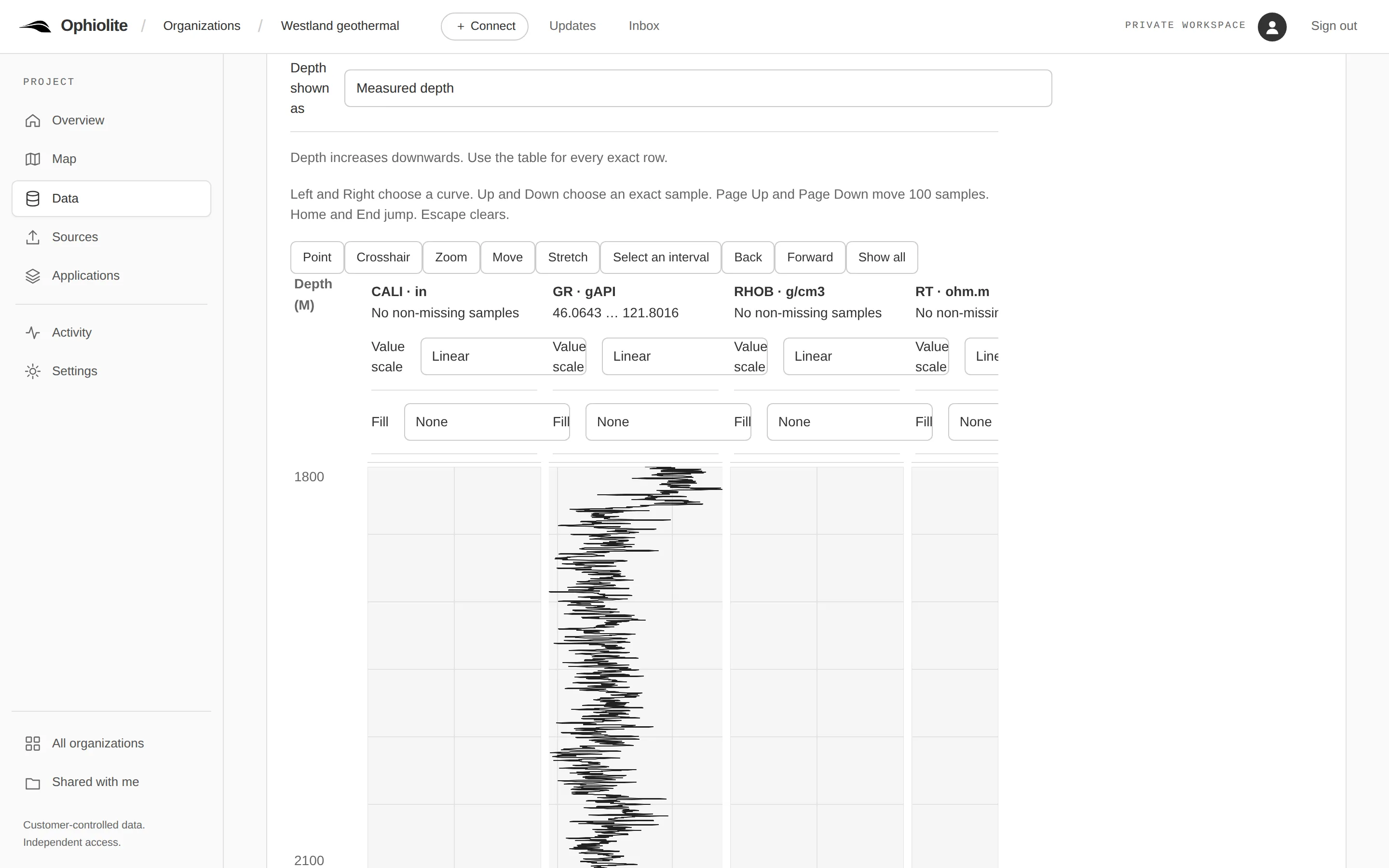
Open the exact version you mean, put an original beside a result and see what changed. Each kind of data has a viewer made for it, with missing values shown as missing, and review moves one exact version through one set of stages.
Read the guide

A well log open in the Workspace as depth tracks: the gamma-ray curve of the HON-GT-01 composite log drawn from 1,800 to 2,100 metres, beside caliper, density and resistivity tracks that hold no samples in that window.
NLOG.NL, Dutch subsurface portal (TNO / Geological Survey of the Netherlands): HON-GT-01, HON-GT-01-S1 and HON-GT-02 composite logs, retrieved 10–11 September 2026; the despiked curve is a demonstration edit. Terms: NLOG disclaimer (LicenseRef-NLOG-Disclaimer-2016-08-09). Captured 2026-10-29 from release 2026.10.122-amd64.

Applications

Partial

QGIS, OpendTect and your own code connect to one project on your own server. Each application checks for a newer version, gets it or sends its own, and nothing changes in an application until a person chooses. The table below says which application works with which kind of data today.

Read the guide

One project between your data and your applicationsData comes in from files, databases and uploads. Your project, on your own server, keeps every version, who sent it and which application received it (today). Your applications check for updates, get the latest version and send to the project: QGIS, your own code, OpendTect, ResInsight and more; the support table says which kinds of data each one handles.Where datacomes fromfiles, databases,uploadsYour projecton your own serverEvery version keptWho sent each oneWhich applicationreceived ittodayYour applicationsQGISYour own codeOpendTectResInsightand more
Which applications work with which kinds of dataA grid of 18 applications and 14 kinds of data by direction; each filled cell carries a status mark. The table below the drawing gives every cell in words, with its limits.QGISOpendTectResInsightYour codeTyped uploadNLOGOSDU recordsOraclePostgreSQLSQL ServerPublic featuresGeoTIFF filesLAS uploadPG tablesSQLite tablesSQLiteTable uploadSection uploadWell logs · readWell logs · writeWells · readWells · writeTops and deviation · readWell paths · readWell sets · readTime-depth · readSurfaces and grids · readSurfaces and grids · sendPoints and faults · readSeismic · readSections and wavelets · readRecords · read✓*✓*✓*✓*✓*✓*✓*?✓*✓*✓*✓*✓*✓*✓*?✓*?✓*???✓*†?✓*?✓*✓*?✓*✓*?✓*?✓*?????✓ works today · ✓* works today, with limits · ? not verified · ◐ in preparation · ○ planned · † the evidence disagrees
Marks are generated from the record of each connector; a blank cell means nothing is claimed.
ApplicationDataDirectionStatusTested onLimits
Your codeWell logsreadsworks today, with limitsPython
  • Preview (0.x) release; Windows is not yet qualified
NLOG public repositoryWell logsreadsworks today, with limitsNLOG (www.nlog.nl, www.gdngeoservices.nl) 2026-10-12, Linux
  • The exact bytes NLOG serves; composite logs by default, other LAS files on request
  • Read from NLOG's public services as NLOG serves them on the day; an older version is kept only once copied in
  • Every copy carries NLOG's source sentence, retrieval date and terms link
  • Not supported, not qualified: tie-in points (kept in the record, not added as stations)
  • Not supported, not qualified: long stratigraphic unit names (unit codes only)
  • Not supported, not qualified: checkshots
  • Not supported, not qualified: core tables
  • Not supported, not qualified: 2D seismic lines
OSDU recordsWell logsreadsworks today, with limitsOSDU Data Platform, Linux
  • Bounded Parquet fidelity
  • Not supported, not qualified: writing to OSDU
LAS file uploadWell logsreadsworks today, with limitsWeb browser, Linux
  • LAS formatting is kept only in the exact original
  • Not supported, not qualified: LAS 3
  • Not supported, not qualified: automatic re-upload
OpendTectWell logswritesworks today, with limitsOpendTect Free 7.0.10, Linux
  • Float32 values and depth
  • missing endpoints absent in native log
  • gamma unit label canonicalized to API
  • Not supported, not qualified: source overwrite
  • Not supported, not qualified: resampling
  • Not supported, not qualified: automatic synchronization
  • Not supported, not qualified: Windows/macOS
Your codeWell logswritesworks today, with limitsPython
  • Preview (0.x) release; Windows is not yet qualified
QGISWellsreadsworks today, with limitsQGIS 4.2.2, Linux
  • A well without coordinates is left out of the layer
  • Display styling is QGIS-side and not returned
  • Not supported, not qualified: editing in place
  • Not supported, not qualified: sending a layer from QGIS
Tops, survey, time-depth, grid, fault and seismic uploadWellsreadsnot verifiedWeb browser
  • JSON formatting is kept only in the exact original
  • Not supported, not qualified: CRS transformation at upload
  • Not supported, not qualified: more than one well per file
NLOG public repositoryWellsreadsworks today, with limitsNLOG (www.nlog.nl, www.gdngeoservices.nl) 2026-10-12, Linux
  • Position from the coordinates NLOG recorded at submission (RD or ED50-UTM31); otherwise NLOG's map point in ED50-UTM31, to the nearest metre
  • Elevation reference is not stated
  • Read from NLOG's public services as NLOG serves them on the day; an older version is kept only once copied in
  • Every copy carries NLOG's source sentence, retrieval date and terms link
  • Not supported, not qualified: tie-in points (kept in the record, not added as stations)
  • Not supported, not qualified: long stratigraphic unit names (unit codes only)
  • Not supported, not qualified: checkshots
  • Not supported, not qualified: core tables
  • Not supported, not qualified: 2D seismic lines
Oracle well headers and tablesWellsreadsworks today, with limitsOracle Database 23ai Free, Linux
  • Only mapped columns are read
  • Coordinates are as stored; the declared CRS is not transformed
  • Tables are read in pages of 1,000 rows inside one read-only transaction, up to 100,000 rows and 64 MiB
  • A read that outlasts the undo is refused: "The table changed while it was read; read it again"
  • TIMESTAMP values keep six fraction digits; further fraction digits are dropped
  • TIMESTAMP WITH TIME ZONE and WITH LOCAL TIME ZONE columns refuse the read when they hold a value (the driver returns no zone)
  • An empty string is NULL in Oracle, so an empty identity refuses the read and an empty name is missing
  • CHAR and NCHAR values keep their trailing padding
  • Unquoted names are upper case: a configured name is used as written when it exists, else upper case; column names are as stored
  • Oracle connections check the certificate's subject name; alternative names are not checked by the driver
  • A statement the server does not interrupt can run past the time limit
  • Not supported, not qualified: writes
  • Not supported, not qualified: operating-system, Kerberos, wallet-only or proxy sign-in
  • Not supported, not qualified: connect descriptors, TNS aliases, SIDs and failover address lists
  • Not supported, not qualified: listener redirects
  • Not supported, not qualified: unencrypted connections
  • Not supported, not qualified: Oracle Client (thick mode)
  • Not supported, not qualified: change data capture
  • Not supported, not qualified: schema changes without a new reviewed mapping
PostgreSQL well headersWellsreadsworks today, with limitsPostgreSQL 16, Linux, web browser
  • Only mapped columns are read
  • Coordinates are as stored; the declared CRS is not transformed
  • Tables are read in pages of 1,000 rows inside one read-only snapshot, up to 100,000 rows and 64 MiB
  • Not supported, not qualified: change data capture
  • Not supported, not qualified: curves in SQL
  • Not supported, not qualified: schema changes without a new reviewed mapping
SQL Server well headers and tablesWellsreadsworks today, with limitsSQL Server 2022, Linux
  • Only mapped columns are read
  • Coordinates are as stored; the declared CRS is not transformed
  • Tables are read in pages of 1,000 rows inside one snapshot-isolation transaction, up to 100,000 rows and 64 MiB; a database without snapshot isolation is inspected but not captured
  • datetime2 and datetimeoffset values keep six fraction digits; the seventh fraction digit is dropped
  • char and nchar values keep their trailing padding
  • Not supported, not qualified: writes
  • Not supported, not qualified: Windows, Kerberos or Entra ID sign-in
  • Not supported, not qualified: named instances and failover partners
  • Not supported, not qualified: unencrypted connections
  • Not supported, not qualified: change data capture
  • Not supported, not qualified: schema changes without a new reviewed mapping
SQLite well locationsWellsreadsworks today, with limitsSQLite 3, Linux
  • Only mapped columns are read
  • Tables are read in pages of 1,000 rows inside one read-only snapshot, up to 100,000 rows and 64 MiB
  • Not supported, not qualified: files outside the gateway allowlist
PostgreSQL well headersWellswritesworks today, with limitsPostgreSQL 16, Linux, web browser
  • Only explicitly granted columns are written
  • Not supported, not qualified: creating or deleting rows
QGISTops and deviationreadsworks today, with limitsQGIS 4.2.2, Linux
  • Opened as an OGC API - Features layer: each top at its wellbore’s location, the newest version you may read
  • A top whose wellbore has no location you may read is listed without a place on the map
  • Display styling is QGIS-side and not returned
  • Opened as an OGC API - Features layer: each survey drawn from its wellbore’s location by minimum curvature, the newest version you may read
  • A survey from true north, or one that does not start at its depth datum, is listed without a line
  • Not supported, not qualified: editing in place
  • Not supported, not qualified: an older version of the item
Tops, survey, time-depth, grid, fault and seismic uploadTops and deviationreadsnot verifiedWeb browser, Linux
  • Text formatting is kept only in the exact original
  • Columns other than Surface, MD and Well are kept only in the exact original
  • Not supported, not qualified: tie-in point
  • Not supported, not qualified: magnetic declination
  • Not supported, not qualified: absolute positions
  • Not supported, not qualified: unit conversion
  • Not supported, not qualified: several wells in one file
  • Not supported, not qualified: reading Z or other vertical coordinates
  • Not supported, not qualified: residuals at wells
NLOG public repositoryTops and deviationreadsworks today, with limitsNLOG (www.nlog.nl, www.gdngeoservices.nl) 2026-10-12, Linux
  • Tops of NLOG's preferred interpretation only; no base row is added
  • Depth basis is not stated
  • Read from NLOG's public services as NLOG serves them on the day; an older version is kept only once copied in
  • Every copy carries NLOG's source sentence, retrieval date and terms link
  • Azimuth reference is not stated; NLOG's north reference code and convergence are kept in the record
  • Depth unit is metres only when NLOG's end depth matches the deepest top and station
  • Not supported, not qualified: tie-in points (kept in the record, not added as stations)
  • Not supported, not qualified: long stratigraphic unit names (unit codes only)
  • Not supported, not qualified: checkshots
  • Not supported, not qualified: core tables
  • Not supported, not qualified: 2D seismic lines
Tops, survey, time-depth, grid, fault and seismic uploadWell pathsreadsnot verifiedWeb browser
  • Text formatting is kept only in the exact original
  • Inclination and azimuth are computed from the package's tangent vectors; the package states no angles
  • Objects other than well paths, trajectories with tangents and well logs are listed as not read, by uuid
  • Not supported, not qualified: inclination and azimuth (use a deviation survey)
  • Not supported, not qualified: conversion between units or datums
  • Not supported, not qualified: more than 10,000 stations
  • Not supported, not qualified: horizons, faults and grids (a later slice)
  • Not supported, not qualified: rotated lattices
  • Not supported, not qualified: packages above 32 MiB with the .h5
  • Not supported, not qualified: sending in parts
  • Not supported, not qualified: bundle export of the items read from a package
QGISWell setsreadsworks today, with limitsQGIS 4.2.2, Linux
  • A member without a frame is listed without geometry
  • Display styling is QGIS-side and not returned
  • Not supported, not qualified: editing in place
  • Not supported, not qualified: sending a layer from QGIS
Tops, survey, time-depth, grid, fault and seismic uploadWell setsreadsnot verifiedWeb browser
  • JSON formatting is kept only in the exact original
  • Not supported, not qualified: saving on this deployment (a set is read, then refused, in this version)
  • Not supported, not qualified: sending in parts
  • Not supported, not qualified: sharing with others
  • Not supported, not qualified: more than 29 members
  • Not supported, not qualified: documents above 256 KiB
Tops, survey, time-depth, grid, fault and seismic uploadTime-depthreadsnot verifiedWeb browser
  • Text formatting is kept only in the exact original
  • The velocity column is kept as stated; it is not recomputed from the pairs
  • Not supported, not qualified: Excel workbooks (.xls, .xlsx)
  • Not supported, not qualified: interpolation, depth-time conversion or a datum default
  • Not supported, not qualified: more than 100,000 pairs
QGISSurfaces and gridsreadsnot verifiedQGIS 4.2.2, macOS, Linux
  • Display styling is QGIS-side and not returned
  • A newer version is shown only when the person chooses Get latest; a check never changes the map
  • Drawn as a 64-bit raster with missing cells left empty; display styling is QGIS-side and not returned
  • Opened as a mesh: values are exact at the points and interpolated linearly in each triangle
  • Attributes beyond the height are properties
  • Not supported, not qualified: editing in place
  • Not supported, not qualified: following the newest version automatically
  • Not supported, not qualified: sending a horizon grid from QGIS
  • Not supported, not qualified: a grid whose coordinate system is not stated
  • Not supported, not qualified: sending a surface from QGIS
  • Not supported, not qualified: points without a value (the surface is not drawn)
  • Not supported, not qualified: a surface whose coordinate system is not stated
  • Not supported, not qualified: sending a layer from QGIS
ResInsightSurfaces and gridsreadsworks today, with limits
The evidence for this cell disagrees
Technical details

The route's profile is not in the connector profile registry

ResInsight, Linux
  • Synthetic local coordinates in the pilot
  • Not supported, not qualified: writing into ResInsight
  • Not supported, not qualified: Mac qualification
Tops, survey, time-depth, grid, fault and seismic uploadSurfaces and gridsreadsnot verifiedWeb browser, Linux
  • Text formatting is kept only in the exact original
  • Comment lines and number spelling are kept only in the exact original
  • Number spelling and spacing are kept only in the exact original
  • Not supported, not qualified: rotated grids
  • Not supported, not qualified: CRS transformation
  • Not supported, not qualified: interpolation
  • Not supported, not qualified: mesh editing
  • Not supported, not qualified: non-triangular faces
  • Not supported, not qualified: unit conversion
  • Not supported, not qualified: time-to-depth
  • Not supported, not qualified: a coordinate system stated without an EPSG code
  • Not supported, not qualified: inferring a grid the header does not declare
  • Not supported, not qualified: inferring corner registration
  • Not supported, not qualified: inferring corner registration or column direction
  • Not supported, not qualified: IRAP binary
GeoTIFF filesSurfaces and gridsreadsworks today, with limitsFile system, Linux, macOS
  • Only band 1 is read
  • Horizontal CRS conversion is limited to the qualified pair
  • Not supported, not qualified: multi-band rasters
  • Not supported, not qualified: vertical datum shifts
QGISSurfaces and gridssends to the projectnot verifiedQGIS 4.2.2, macOS, Linux
  • Styling, layer order and QGIS processing history are not sent
  • A result from a managed source, or one that changes the meaning or grid, is sent as a separate map
  • Not supported, not qualified: sending from a map opened through a connection file
  • Not supported, not qualified: merging two changes to one map
QGISPoints and faultsreadsworks today, with limitsQGIS 4.2.2, Linux
  • Points without a height are drawn flat; their height field is empty
  • Display styling is QGIS-side and not returned
  • Opened as a GeoPackage copy on this computer; edits stay in that copy until you send them or keep them as a separate layer
  • Opened as one line per stick, its points in their stored order
  • A stick of one point opens without geometry
  • Measured values (M) on shapes are not kept
  • A field whose name QGIS reserves is renamed attribute_<name>
  • Not supported, not qualified: a point set whose coordinate system is not stated
  • Not supported, not qualified: following the newest version automatically
  • Not supported, not qualified: a set of sticks whose coordinate system is not stated
  • Not supported, not qualified: a layer that does not state its coordinate system or coordinate order
Your codePoints and faultsreadsworks today, with limitsPython
  • Preview (0.x) release; Windows is not yet qualified
Tops, survey, time-depth, grid, fault and seismic uploadPoints and faultsreadsnot verifiedWeb browser
  • Text formatting is kept only in the exact original
  • Inline and crossline per point are kept only in the exact original
  • Formatting and anything the feature set does not hold are kept only in the exact original
  • Not supported, not qualified: CRS transformation
  • Not supported, not qualified: text attributes
  • Not supported, not qualified: fault surfaces (triangulated planes)
  • Not supported, not qualified: unit conversion
  • Not supported, not qualified: time-to-depth
  • Not supported, not qualified: a coordinate system stated without an EPSG code
  • Not supported, not qualified: joining sticks of one fault that the file writes apart
  • Not supported, not qualified: multipatch
  • Not supported, not qualified: axis swapping
  • Not supported, not qualified: attribute types other than text, numbers, dates and true/false
  • Not supported, not qualified: GeoPackage 1.0 and 1.1
  • Not supported, not qualified: curved geometries
  • Not supported, not qualified: more than one layer per upload
  • Not supported, not qualified: tiles and attributes-only tables
  • Not supported, not qualified: GeometryCollection
  • Not supported, not qualified: mixed geometry kinds
  • Not supported, not qualified: nested property values
Features from another public servicePoints and faultsreadsworks today, with limitsOGC API - Features and WFS 2.0 (PDOK, NLOG) 2026-10-12, Linux
  • Feature ids are not kept
  • Positions in the coordinate system the service states; nothing is transformed
  • Nested property values are kept only in the exact original
  • Only the first 10,000 features of a collection are read; the report says when more exist
  • Read from the service as it answers on the day; an older version is kept only once copied in
  • Every copy carries the service's licence as its own documents state it, or says it is not stated
  • Not supported, not qualified: CRS transformation
  • Not supported, not qualified: a coordinate system the service reprojects with an offset (NLOG: its own system only)
  • Not supported, not qualified: GeometryCollection
  • Not supported, not qualified: mixed geometry kinds
  • Not supported, not qualified: XML (GML) output
Your codeSeismicreadsworks today, with limitsPython
  • Preview (0.x) release; Windows is not yet qualified
Tops, survey, time-depth, grid, fault and seismic uploadSeismicreadsnot verifiedWeb browser
  • Slice samples are converted to float64 exactly; header interpretations are recorded as decisions
  • Samples are not copied into the description; header interpretations are recorded as decisions
  • Not supported, not qualified: SEG-Y formats other than IBM and IEEE float
  • Not supported, not qualified: little-endian or variable-length traces
  • Not supported, not qualified: irregular grids
  • Not supported, not qualified: volume export
  • Not supported, not qualified: a 2D SEG-Y file without the exporter's marker (it is read as a seismic volume)
  • Not supported, not qualified: lines of more than 200,000 traces
  • Not supported, not qualified: line export
Your codeSections and waveletsreadsworks today, with limitsPython
  • Preview (0.x) release; Windows is not yet qualified
Wavelet, rock model and seismic section uploadSections and waveletsreadsnot verifiedWeb browser
  • Text formatting is kept only in the exact original
  • The declared frequency is recorded as written; it is not checked against the samples
  • Not supported, not qualified: wavelet estimation from data
  • Not supported, not qualified: phase rotation
  • Not supported, not qualified: sample intervals outside 0.0005-0.01 s
  • Not supported, not qualified: more than 4095 samples
  • Not supported, not qualified: property grids (one rock index per cell only)
  • Not supported, not qualified: map position
  • Not supported, not qualified: more than 1,000,000 cells
  • Not supported, not qualified: 2D SEG-Y lines
  • Not supported, not qualified: depth-to-time conversion
  • Not supported, not qualified: more than 1,000,000 samples
OSDU recordsRecordsreadsworks today, with limitsOSDU Data Platform, Linux
  • Only approved kinds and fields
  • Not supported, not qualified: writing to OSDU
  • Not supported, not qualified: general raster kinds
Oracle well headers and tablesRecordsreadsnot verifiedOracle Database 23ai Free, Linux
  • Columns of types outside the eight logical types (spatial geometry, XMLTYPE, BLOB, CLOB, RAW and others) are listed as not read; their values are not delivered and a change in them is not detected
  • Declared units, descriptions, missing-value markers and coordinates are annotations; no value is converted
  • A table is read once inside one read-only transaction, up to 100,000 rows, 64 MiB and 128 columns
  • DATE is a timestamp with its time of day; TIMESTAMP WITH TIME ZONE values are delivered in UTC without their original offset
  • An empty string is NULL in Oracle
  • CHAR and NCHAR values keep their trailing padding
  • Oracle connections check the certificate's subject name; alternative names are not checked by the driver
  • A statement the server does not interrupt can run past the time limit
  • Not supported, not qualified: writes
  • Not supported, not qualified: change data capture
  • Not supported, not qualified: paging past the bounds
  • Not supported, not qualified: years before 1
  • Not supported, not qualified: schema changes without a new reviewed declaration
SQL Server well headers and tablesRecordsreadsnot verifiedSQL Server 2022, Linux
  • Columns of types outside the eight logical types (geography, xml, varbinary and others) are listed as not read; their values are not delivered and a change in them is not detected
  • Declared units, descriptions, missing-value markers and coordinates are annotations; no value is converted
  • A table is read once inside one snapshot-isolation transaction, up to 100,000 rows, 64 MiB and 128 columns; a database without snapshot isolation is inspected but not captured
  • char and nchar values keep their trailing padding
  • Not supported, not qualified: writes
  • Not supported, not qualified: change data capture
  • Not supported, not qualified: paging past the bounds
  • Not supported, not qualified: schema changes without a new reviewed declaration
PostgreSQL tablesRecordsreadsnot verifiedPostgreSQL 16, Linux
  • Columns of types outside the eight logical types are listed as not read; their values are not delivered and a change in them is not detected
  • Declared units, descriptions, missing-value markers and coordinates are annotations; no value is converted
  • A table is read once inside one read-only snapshot, up to 100,000 rows, 64 MiB and 128 columns
  • Not supported, not qualified: writes
  • Not supported, not qualified: change data capture
  • Not supported, not qualified: paging past the bounds
  • Not supported, not qualified: schema changes without a new reviewed declaration
SQLite tablesRecordsreadsnot verifiedSQLite 3, Linux, macOS
  • Columns of types outside the eight logical types are listed as not read; their values are not delivered and a change in them is not detected
  • Declared units, descriptions, missing-value markers and coordinates are annotations; no value is converted
  • SQLite NUMERIC and DECIMAL columns, and columns without a declared type, are not read
  • A table is read once inside one read-only snapshot, up to 100,000 rows, 64 MiB and 128 columns
  • Not supported, not qualified: writes
  • Not supported, not qualified: files outside the gateway allowlist
Table file upload (CSV, Excel, Parquet)Recordsreadsnot verifiedWeb browser
  • Text formatting is kept only in the exact original
  • Formulas are kept only in the exact original; the table holds their stored values
  • Cell styles, merged cells and other sheets are kept only in the exact original
  • Columns of nested or unsupported types are listed as not read and kept only in the exact original
  • Not supported, not qualified: more than 100,000 rows or 128 columns
  • Not supported, not qualified: more than one sheet in one table
  • Not supported, not qualified: nested types (list, struct, map) as columns

Getting data in

Available

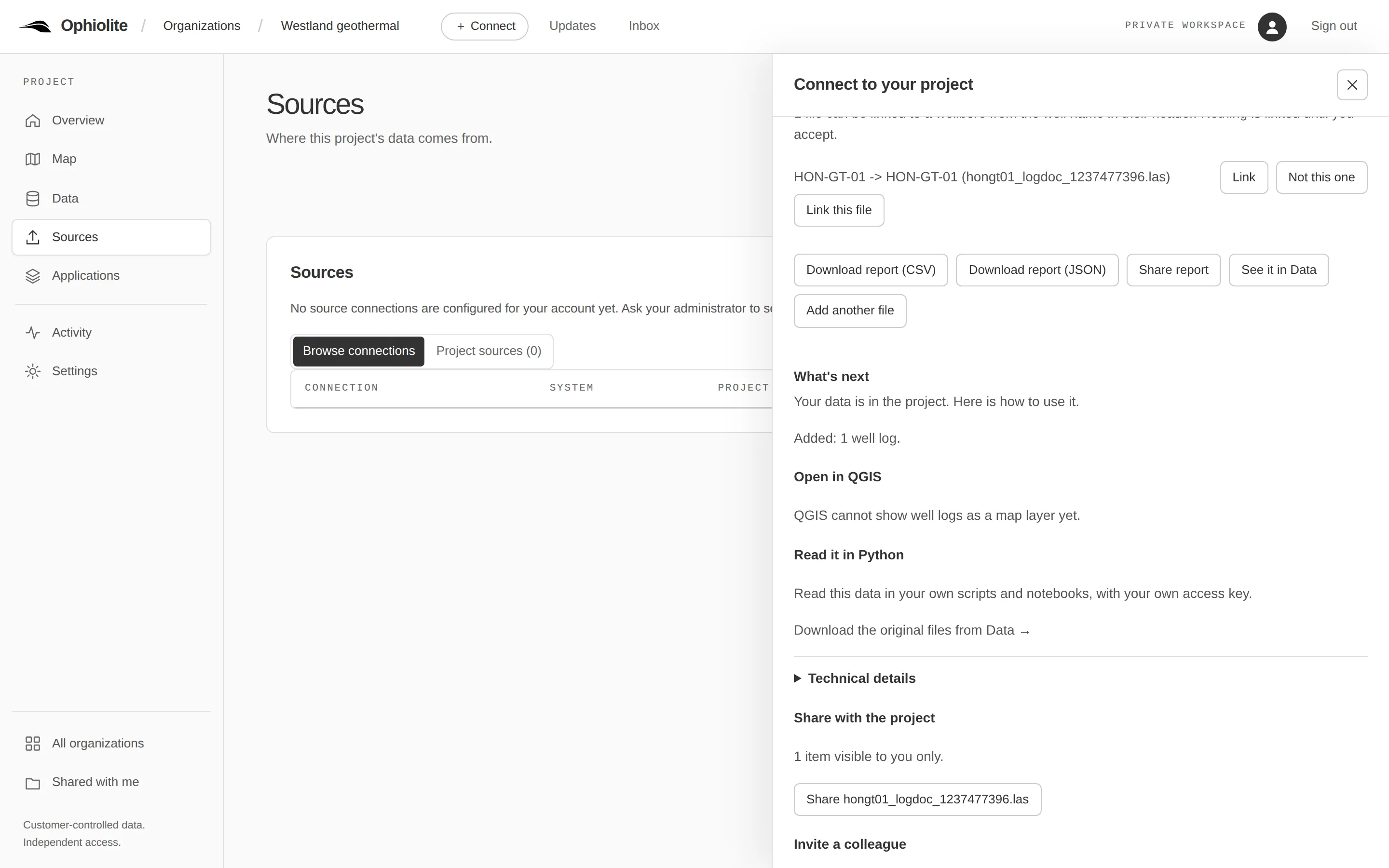
Upload a folder, read a table or connect a source you already keep. Each item becomes an exact version with its source, and one card then says what to do next: open it in QGIS, read it in Python or invite a colleague.
Read the guide

After adding one well log: the link to its wellbore waits to be accepted, and a What's next card says how to use it: not yet as a QGIS map layer, read it in Python, share it with the project, invite a colleague.
NLOG.NL, Dutch subsurface portal (TNO / Geological Survey of the Netherlands): HON-GT-01, HON-GT-01-S1 and HON-GT-02 composite logs, retrieved 10–11 September 2026; the despiked curve is a demonstration edit. Terms: NLOG disclaimer (LicenseRef-NLOG-Disclaimer-2016-08-09). Captured 2026-10-29 from release 2026.10.122-amd64.

Tools

Available

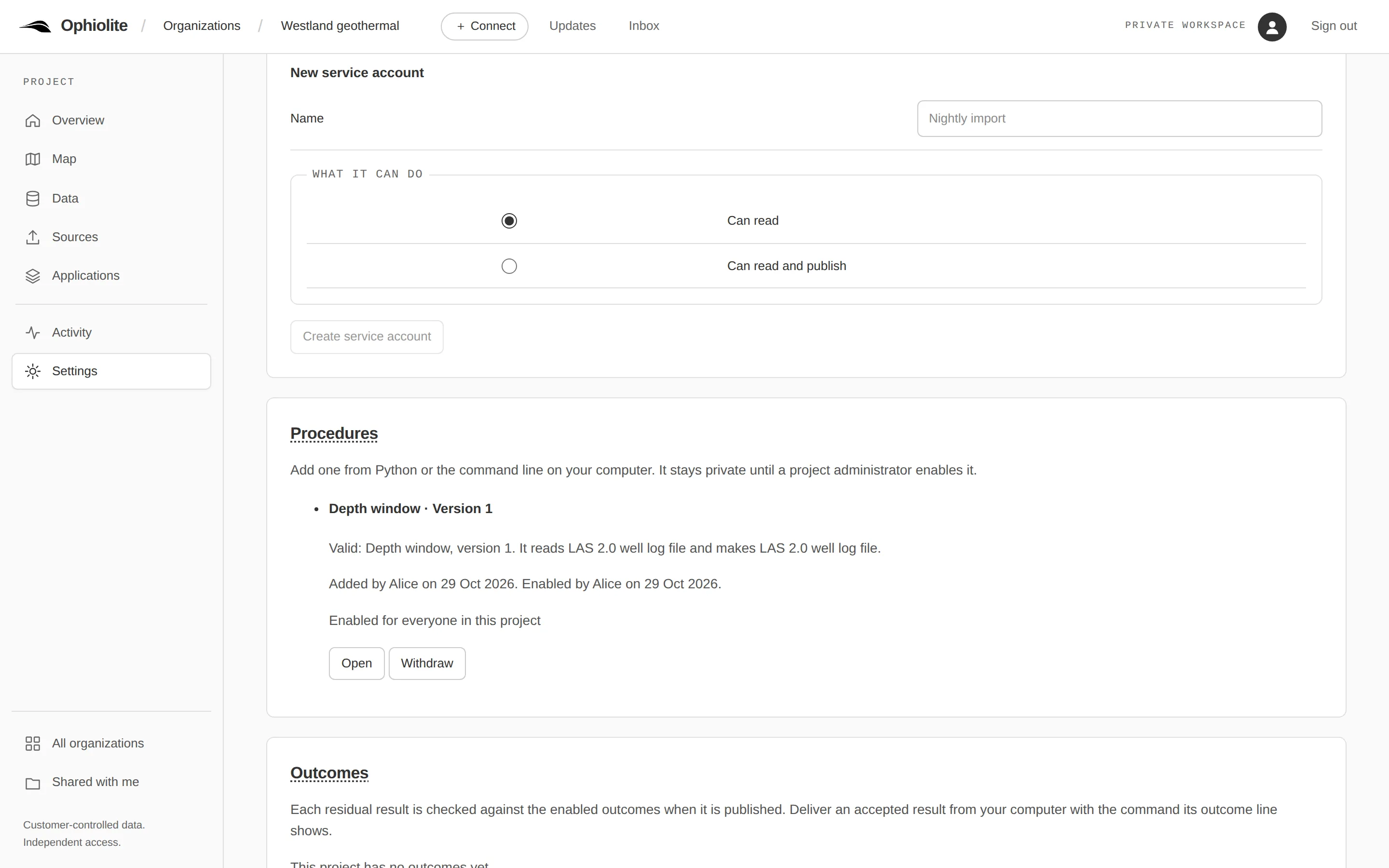
Write a step in Python and run it on your own computer against an exact version. Its result is published with the exact inputs it read, so a colleague can see how it was made and run it again.
Read the guide

Settings: one tool in the project catalogue, Depth window version 1, which reads and makes LAS 2.0 well logs; added from Python and enabled by Alice for everyone in the project.
NLOG.NL, Dutch subsurface portal (TNO / Geological Survey of the Netherlands): HON-GT-01, HON-GT-01-S1 and HON-GT-02 composite logs, retrieved 10–11 September 2026; the despiked curve is a demonstration edit. Terms: NLOG disclaimer (LicenseRef-NLOG-Disclaimer-2016-08-09). Captured 2026-10-29 from release 2026.10.122-amd64.

The record

Available

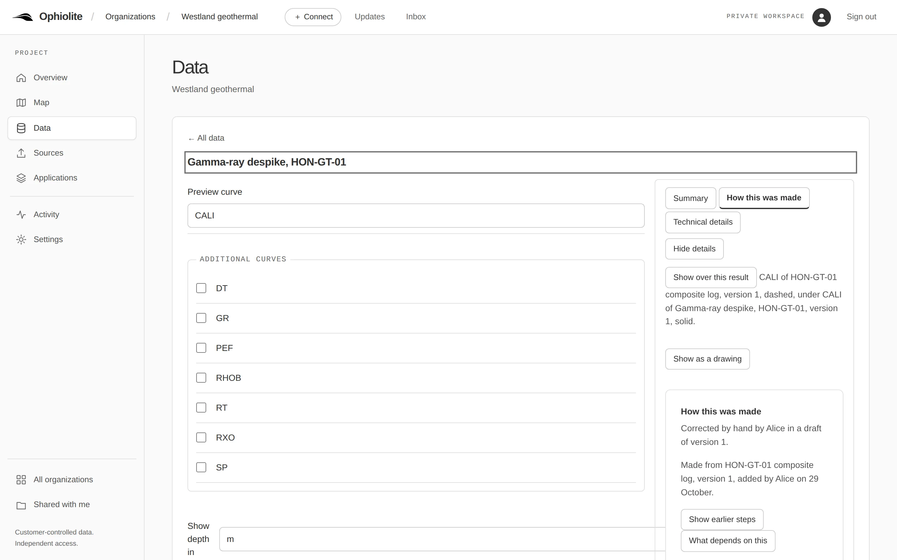
Every action in a project is written down in order, with who did it and when. Each result shows how it was made: by whom, with which method and version, and from which data.
Read the guide

A published result, Gamma-ray despike HON-GT-01, with How this was made open: corrected by hand by Alice in a draft of version 1, made from the HON-GT-01 composite log, version 1.
NLOG.NL, Dutch subsurface portal (TNO / Geological Survey of the Netherlands): HON-GT-01, HON-GT-01-S1 and HON-GT-02 composite logs, retrieved 10–11 September 2026; the despiked curve is a demonstration edit. Terms: NLOG disclaimer (LicenseRef-NLOG-Disclaimer-2016-08-09). Captured 2026-10-29 from release 2026.10.122-amd64.

Agents and AI assistants

Available

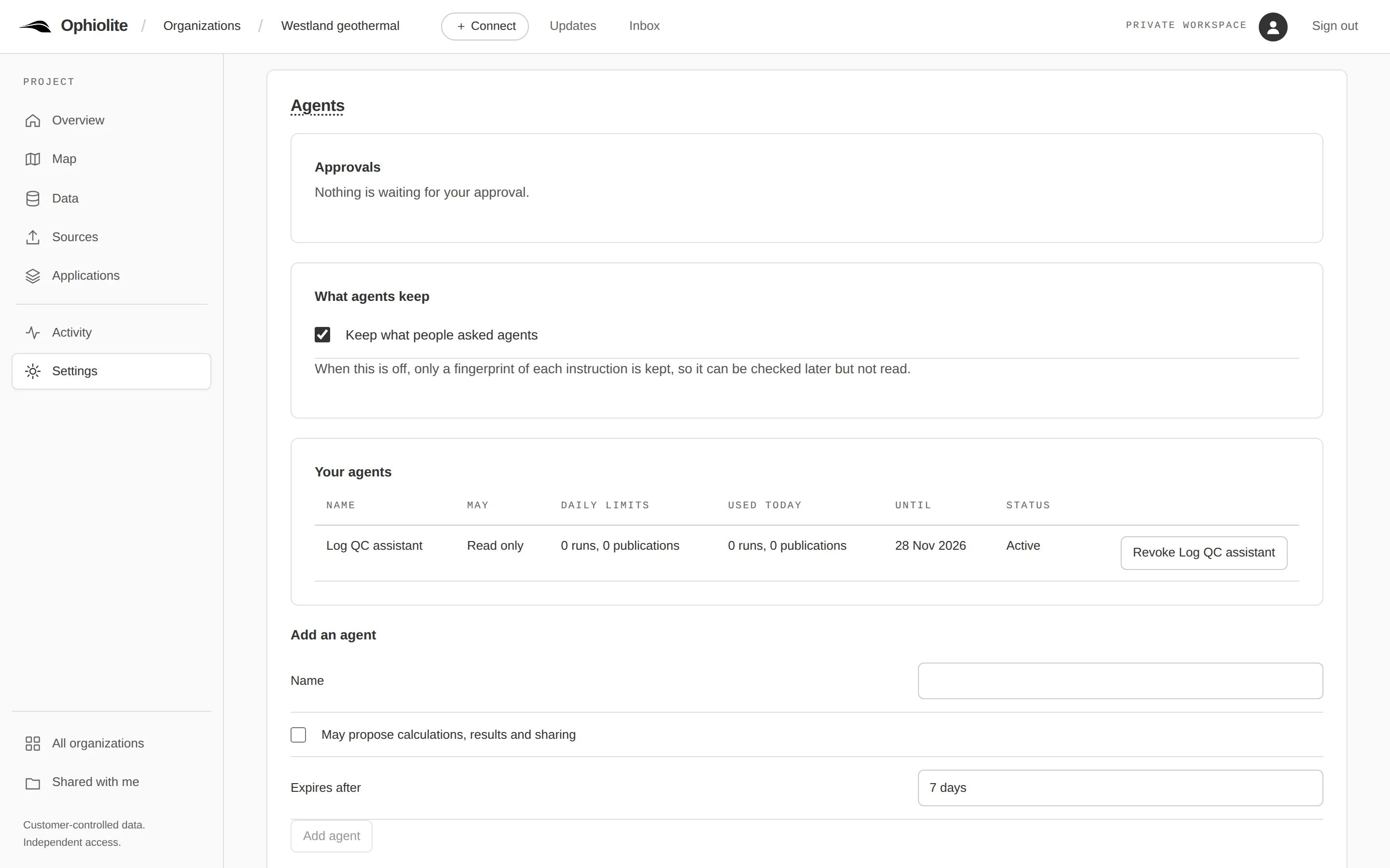
Agents act for you with a scoped key and a daily budget, and every change they want to make waits in an approval inbox as a plan you approve. You set them up in Settings, under Agents, and MCP clients use the project's MCP endpoint. Ophiolite calls no model and hosts none.
Read the guide

Settings, Agents: nothing waiting for approval, what agents keep, and one agent, Log QC assistant, read only, with its daily limits and the date it expires.
NLOG.NL, Dutch subsurface portal (TNO / Geological Survey of the Netherlands): HON-GT-01, HON-GT-01-S1 and HON-GT-02 composite logs, retrieved 10–11 September 2026; the despiked curve is a demonstration edit. Terms: NLOG disclaimer (LicenseRef-NLOG-Disclaimer-2016-08-09). Captured 2026-10-29 from release 2026.10.122-amd64.

Everything, with its status

Every capability, checked against the program's status table each time this site is built.

Capabilities with status and limits
CapabilityStatusLimits
Sign in once, stay signed inSign in through your organisation's sign-in provider or with an access key; one session policy applies to the browser, the SDK and applications.Available—
One typed APIEvery scientific read and write goes through one versioned API with a published schema and generated Python and TypeScript types.Available—
Screens in plain languageScientists see names, units and versions; engineering identifiers stay behind one Technical details disclosure.Available—
Everything the browser does is scriptableThe Workspace is an ordinary client of the public API, so sharing, access and publication can be done from code.Available—
Python SDK, command line and templatesThe ophiolite package reads exact versions into DataFrames and publishes results; templates cover notebooks, scripts, applications and agents.Available
  • Preview (0.x) release; Windows is not yet qualified
Agents that act within your rulesA remote MCP endpoint and scoped agent keys with budgets; every change an agent makes needs a plan you approved.Available
  • Assistant sign-in against your own sign-in provider and automatic assistant approvals are not yet available
Inspect well logs in the browserView a curve, compare the original with a result and see what changed, without leaving the Workspace.Available—
Share work with the right peopleContributors, policy-checked sharing and one set of stages; everyone reads the same exact version.Available—
Run code inside your boundaryAgents and long jobs run in containers with no network, a read-only file system and resource limits.Available
  • No GPU or distributed scheduling
AI use you can permit and auditPer-reader permission by purpose, whole-or-nothing corpus export and in-boundary search that never calls out.Available
  • No model training or hosting
Portable exitA versioned export bundle with an independent offline reader: reuse your data with no server and no account.Available
  • Streaming past 32 MiB per representation is not yet qualified
One record of data, context and interpretationA single metadata and permission core, so a version fixes the data, its context and its interpretation together.Available—
Wells and wellbores as real thingsTyped wells and wellbores with evidenced associations, navigable in the browser and the SDK.Available—
Adversarially qualifiedAn independent adversarial qualification of the whole chain before release; findings fixed and requalified.Available—
A team journey rehearsed from the public docsThe six-step team journey rehearsed on a clean install from the public documentation, by an agent that did not build it, with no engineer repairs.Available
  • An internal rehearsal, not an external trial
  • QGIS and the two-person run on macOS were not part of it
Access keys, service accounts and hand-overSelf-service scoped access keys, project service accounts with named administrators and an offboarding hand-over.Available—
Check, get and send from your own codeA script asks whether a newer version exists, gets the exact version it chooses and sends its result back; a send based on an older version is refused, never merged.Available—
Who received which versionWhen an application or a script confirms it received a version, the project records which one, and the Activity view shows it under the name of the access key.Available—
Approved plans you can run againA result names who approved its plan, and the plan can run again as a new request.Available—
Numbers checked against a referenceA result can show its check against an independent calculation on named data, and the bound.Available—
Drawn storiesEach result's page draws how it was made as boxes and arrows.Available—
Tools you write and runYour own Python, run on your computer against an exact version; its result is published with the exact inputs recorded.Available—
What to do next, with templates and a sampleAfter an upload, a share or in an empty project, one card says what to do next with the exact thing to copy: the steps and address to open the wells in QGIS (or a plain sentence when QGIS cannot show that kind yet), the Python read, who can see the data and how to invite a colleague; every table target has a downloadable template, and an empty project offers 'Start from the NLOG sample'.Available
  • QGIS opens wells only; tops, deviation, points and grids show a plain cannot-yet sentence until their slices merge
  • The NLOG sample needs a deployment that carries it (the server image does); without it the button says the deployment has no sample data
One installable server imageOne image with backup, restore, upgrade and member and project moves from one operations command.Partial
  • Clean-host qualification on the consolidated composition is still open
  • Available to design partners; there is no public download
Explicit result versionsAppend a result version against its parent, group results, recommend one and compare parameters.Partial
  • Connector-owned inputs are not versioned this way
Your storage, verified readsLocal or S3-compatible object storage with verified range reads.Partial
  • Streaming past 32 MiB per representation is not yet qualified
  • Multi-node storage is not qualified
Well logs, tops, trajectories, surfaces and point setsTyped profiles for logs, tops, trajectories, gridded and triangulated surfaces and point sets.Partial
  • Map features cannot yet be changed to another coordinate system
Connectors with fidelity reportsEach connector declares what it reads and writes and reports what a conversion loses; a packaged QGIS plugin for scalar maps.Partial
  • QGIS host acceptance on macOS is not yet complete
Public conformance suitesOffline, server and agent conformance tasks anyone can run, and a nightly run against a deployment.Partial
  • A model-driven agent test over MCP is not yet part of the suite
Faults and seismic sectionsFault sticks, a SEG-Y reader that records every header decision, verified chunks and seismic sections in the Workspace.Partial
  • Slice reads only; whole-volume streaming is not available
Apache-2.0 foundationApache-2.0 for project-owned code, source publication in preparation; a release-only candidate passes every gate privately.Partial
  • Source publication in preparation; the source is not yet public
Try it on your own computerOne command starts Ophiolite on one Linux computer with public NLOG well headers and a gamma-ray log, signs you in with a single-use link, and removes it all again.Partial
  • Linux on x86_64; the server image also runs on ARM64 Linux, and Try it on a Mac waits for its own record; a Mac with 4 GB for its container engine is refused
  • The image is not yet in a public registry: design partners receive the page with their reference
  • One computer, reachable only from itself; it is an evaluation, not a deployment
A dedicated trial workspace for your organisationYour own Ophiolite at its own address, with its own database and the public NLOG sample, opened with a single-use sign-in link; at the end your work comes back as portable bundles.Partial
  • Run for you by Ophiolite on one trial host; there is no sign-up and no billing
  • Public data only, for 30 days; a removal keeps the backup and your bundles for 30 days
  • QGIS against a dedicated instance has not yet been tried end to end
Check, get and send in QGISEach QGIS layer holds the version it shows; checking never changes the map, and Get latest and Send to project are choices a person makes.Partial
  • Maps, grids, triangulated surfaces, point sets, fault sticks and map features; checked with QGIS 4.2.2 on Linux; macOS and Windows not yet qualified
Look around without an accountA public demonstration: a visitor presses Look around and gets a short read-only visit of the public NLOG sample, without an account; nothing can be changed, and it is reset on a schedule.Partial
  • Read-only: a visitor can look, filter, plot and download, but not upload, edit, compute or invite
  • One shared sample project; visits are short and end at every reset
  • Being set up: there is no public address yet
Configurable scientific ingestionSource packages with companions, versioned import recipes, Petrel points-with-attributes and OpendTect horizon readers.Coming—

Not planned

  • Suite-wide Petrel or Techlog replacement
  • A general application builder or marketplace
  • Universal format conversion